Order Total (1 Item Items):
Shipping Destination:

Antique Print Zeeland Netherlands Kaerius Keere 1617 (1 results)
Skip to main search results
Product Type
- All Product Types
- Books
- Magazines & Periodicals
- Comics
- Sheet Music
- Art, Prints & Posters (1)
- Photographs
- Maps
-
Manuscripts &
Paper Collectibles
Condition
- All Conditions
- New
- Used
Binding
- All Bindings
- Hardcover
- Softcover
Collectible Attributes
- First Edition
- Signed
- Dust Jacket
- Seller-Supplied Images
- Not Printed On Demand
Seller Location
Seller Rating
-
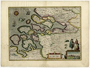
Antique Print-ZEELAND-NETHERLANDS-Kaerius-Keere-1617
Art / Print / Poster
Antique print, untitled. Beautiful hand coloured map of the Province of Zeeland, The Netherlands. With parts of neighboring provinces: Holland and Brabant. At right bottom a view of the capital Middelburg, with 2 figures in contemporary local costume. With a scale to the left of this, surrounded by scrollwork. Petrus Kaerius' publishers impressum just above. At top left a beautiful 32-part compass rose, surrounded by ships and a sea monster. Latin text on rear. Engraving on hand laid paper. Description: Published in Amsterdam in 1617 in Petrus Kaerius' "Germaniae Inferior id est, XVII Provinciarum ejus novae et exactae Tabulae Geographicae. 2 additional ed. were published in 1622. Claes Jansz Visscher acquired the plates from this Atlas after Karerius'' death and republished the maps in 1631 with alterations, after which they passed on to Henricus Hondius en Johannes Janssonius who published the maps in "Atlas ofte afbeeldinghe van de gantsche Weereldt [.]", in 1634.Artists and Engravers: Made by 'Pieter van der Keere / Kaerius' after an anonymous artist. Petrus Kaerius (also Pieter van den Keere, 1571-1646), was a Dutch engraver and publisher. Persecuted in his country because of his religious orientation he moved to London. As brother-in-law to famous Jodocus Hondius (who had also fled to London) he became his ardent student learning from him the art of engraving and mapmaking. Kaerius published individual maps, but also atlases of the Netherlands and of Great Britain. Condition: Very good, given age. Paper edges a bit irregular, with some chipping and tiny holes. Original middle fold as issued. Bottom middle fold wioth some professional restaurations, barely visible. Some remains of tape from previous attachment. General age-related toning and/or occasional minor defects from handling. Please study scan carefully. Storage location: B16-06 The overall size is ca. 22.4 x 17.1 inch. The image size is ca. 18.5 x 13.8 inch. The overall size is ca. 57 x 43.5 cm. The image size is ca. 47 x 35 cm.